Geophysical Studies


At CRA, we stress the use of multiple survey techniques to gain maximum information in a cost efficient manner. That’s why, since 1987, CRA has pioneered the integration of near-surface geophysical techniques with fieldwork to reduce costs and improve the quality of cultural resource evaluations. Also referred to as geophysics or geophyz, geophysical survey harnesses state-of-the-art data collection techniques, including magnetometry, electromagnetic induction (electrical conductivity and magnetic susceptibility), electrical resistivity, and ground-penetrating radar (GPR) to locate potential archaeological sites. No matter the technique, we emphasis using high speed, high-density data collecting field equipment and state of the art processing routines that allows us to continually increase the utility and accuracy of geophysical survey data. In keeping with CRA’s dedication to using the cutting-edge geophysical techniques, a push-cart magnetometer system MAGNETO® MXPDA was recently acquired by the company. The new system will allow CRA’s geophysical specialist to produce even more efficient results.
Near-surface geophysical survey techniques are rapid, non-destructive techniques for identifying all manner of past occupation. From identifying complete settlements to seasonal camp sites, applying the right geophysical technique can lead to a significantly better understanding of archaeological sites. In an ideal world, geophysics would be performed before and in tandem with traditional survey and excavation, but we at CRA recognize the need for efficient cost effective solutions and work with our clients to employ the most appropriate survey, case by case. They are ideally suited to Phase I and II fieldwork as a substitute for strip plowing, general plowing or disking, or dozer/pan “scrapes.” Especially where survey and evaluation occur well in advance of mitigation and construction, these techniques can provide an attractive alternative to things such as badly damaged fields. Additionally, they are able to overcome sampling issues posed by systematic shovel testing and can be considerably faster than shovel testing. When used correctly in combination with analysis of cartographic resources and other background data, the results of a geophysical survey may provide significant primary data to be used in decision making processes and at minimum better inform decisions about how to best deploy more cost-intensive field operations such as shovel testing, sample block excavation, strip plowing, and dozer scrapes.
Remote Sensing Studies
At CRA we incorporate the use of remote sensing technologies where and when applicable. In a broad sense, remote sensing encompasses all technologies that allow for the remote collection of data through specialized equipment which includes geophysics. However, given the often different project needs and goals, we separate our non-geophysical work into other areas.
With increased computing power and optimized algorithms Structure-from-motion (SfM) photogrammetry has become easily accessible to professionals and the public alike. This method creates full 3D reconstructions from multiple overlapping images which can be used for aerial or terrestrial mapping of the landscape or close range mapping of objects. SfM can achieve high accuracy and precision comparable to light detection and ranging (Lidar/Laser Scanning). Lidar also can achieve these high levels of accuracy, but requires more specialized equipment, translating to higher costs. We work with our clients to determine which method best fits their project needs.
Geophysical Investigations and Project Planning

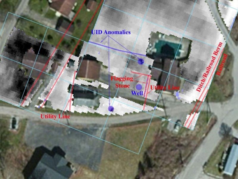
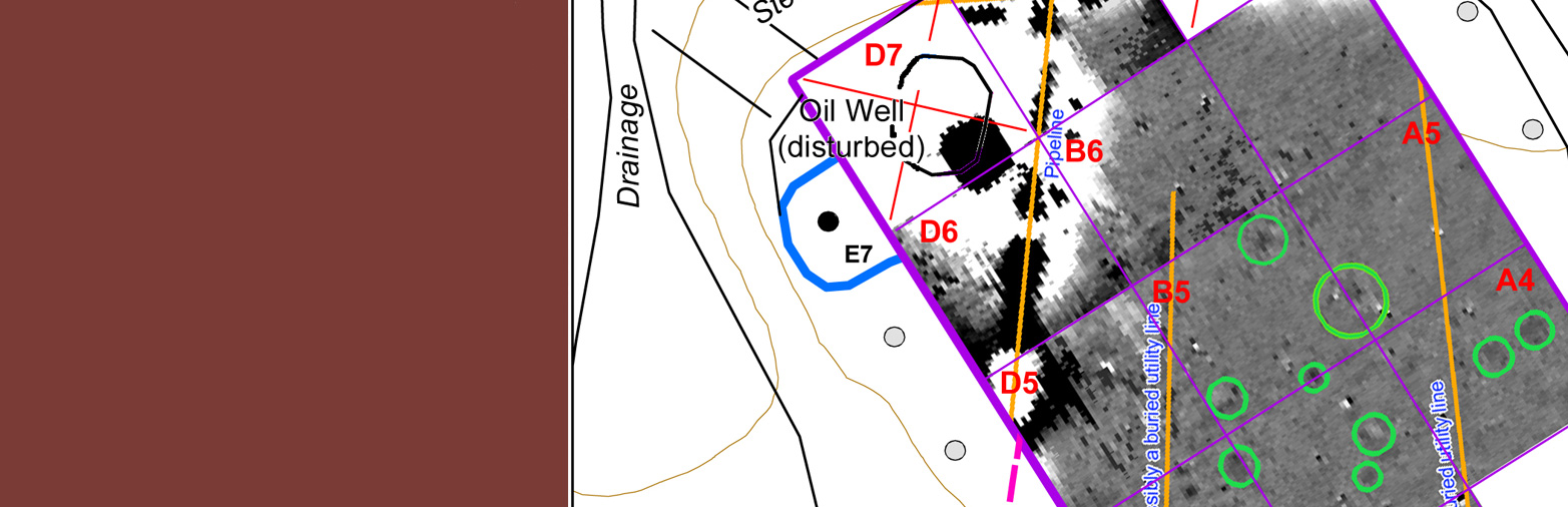
Geophysical studies can serve a critical benefit at the project planning phase, ultimately helping to guide decision-making processes as they relate to potential project locations. Such studies can, for example, help to more concretely identify the potential for below-ground features prior to any ground disturbance and minimize the degree to which broad-scale archaeological survey may be required in favor of a more targeted approach. Reflecting the importance of geophysical studies at the project planning stage is our work for the U.S. Department of Veterans Affairs at various facilities, including in Ohio. Here, CRA worked with the VA and the environmental prime contractor to conduct targeted geophysical investigations in advance of several construction projects intended to be implemented in accordance with the facility’s master plan and other special initiatives.
Prior to the geophysical survey, aerial photographs, aerial renderings, and historic maps were georeferenced and analyzed to provide target areas for the geophysical survey and archaeological test excavations. Based on analysis of this data and employing a combination of ground-penetrating radar and magnetometry, CRA carried out the investigation with the goal to identify and characterize potential subsurface archaeological resources on the property, particularly those related to the original construction of the property during the mid-nineteenth century. In total, 24 survey areas covering approximately 13 acres were surveyed. The majority of the data was collected with the GPR, although magnetic data also was collected at targeted locations. Potential archaeological targets were ultimately identified in 19 of the 24 survey areas. Archaeological targets included building foundations, building footers, cellars, and landscaping features. Subsurface utilities, past and present, were also documented. The results of the investigation were provided to the archaeology team to help guide the locations and extent of potential archaeological work at the facility prior to construction activities.
Related Projects
Cultural Resource Survey at Richmond International Airport
Archaeology, Geophysical Survey, Land Use and Development, Tennesseeview
Geophysical Survey at the Wainwright Memorial Veterans Affairs Medical Center
Archaeology, Federal, Geophysical Survey, Kentuckyview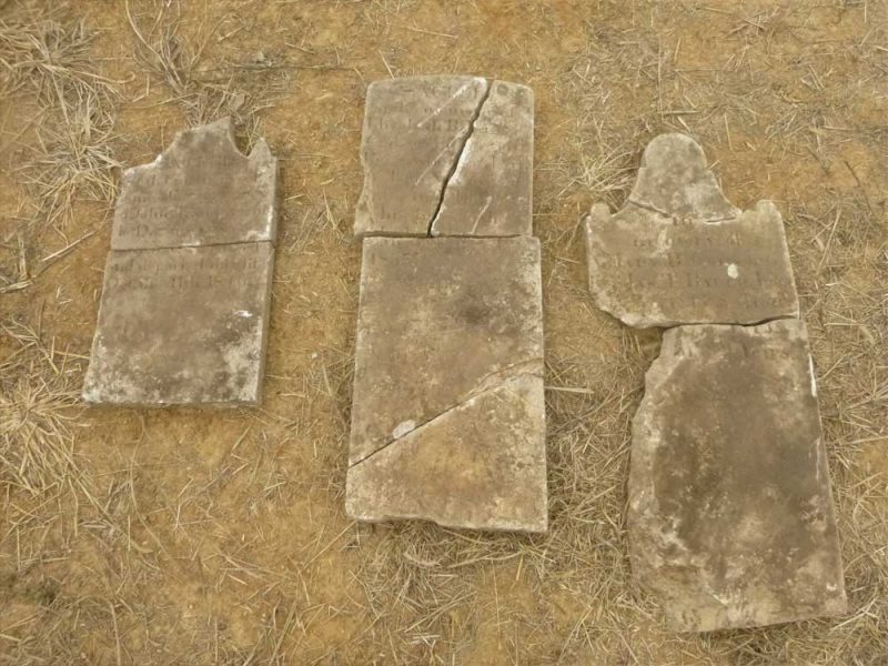
Geophysical Survey of Riggs Cemetery
Archaeology, Geophysical Survey, Land Use and Development, Tennesseeview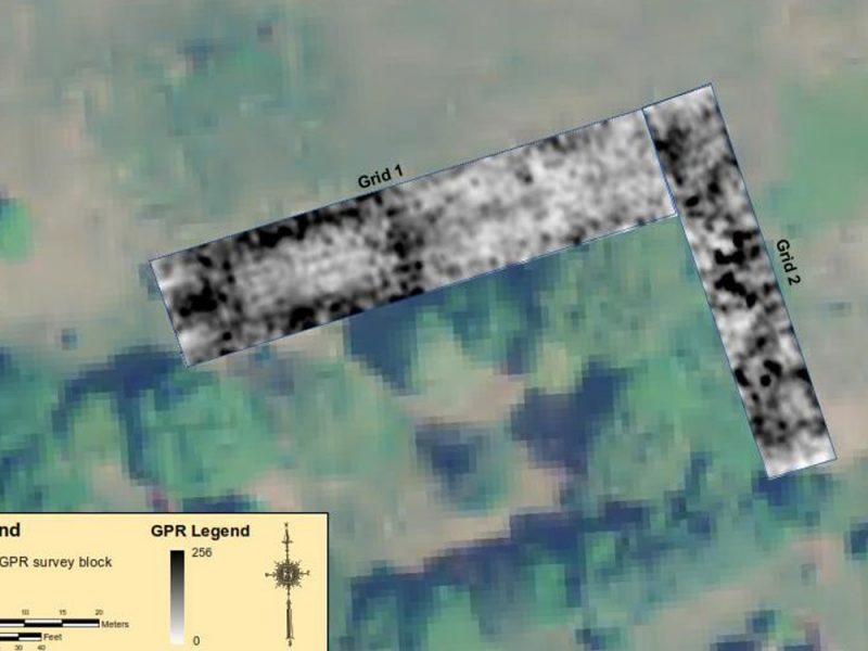
Mars Hill Cemetery Ground-Penetrating Radar Survey
Archaeology, Geophysical Survey, Land Use and Development, Louisianaview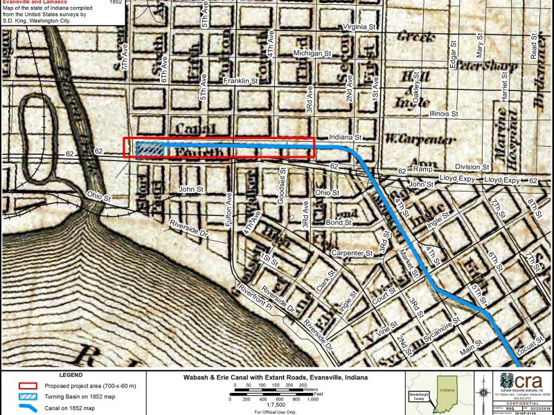
Wabash and Erie Canal Geophysical Survey
Archaeology, Geophysical Survey, Indiana, Local + State, Transportationview